Mule Deer Surveys: Above & Beyond
Mule deer surveys are an important component of managing mule deer populations in the Texas Panhandle. In Texas, large-scale aerial mule deer surveys are conducted by the Texas Parks & Wildlife Department Wildlife Department (TPWD) annually. And as it turns out, counting mule deer is more complicated than you’d think. Biologists don’t simply fly around counting the deer that they observe down below.
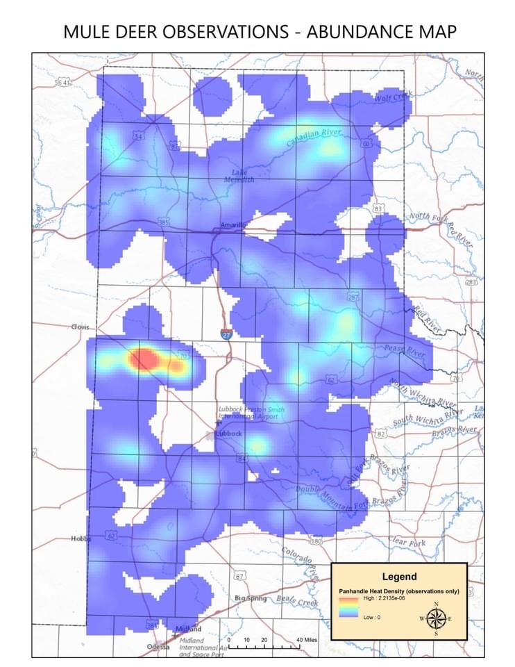
Survey data ensures sound regulations and stable populations for future hunting opportunities. According to TPWD, “The mule deer range in the Texas Panhandle covers a large area and we simply don’t have the resources to survey everything, so the area is divided up into Monitoring Units. Then a computer randomly selects transects.
This helps ensure that we randomly sample the entire area and not just the very best habitat with the most deer. The survey transects are anywhere from 10 to 35 miles in length. We fly them during the winter in a helicopter with a pilot and two observers, going 35-55 mph at a height of 60 feet. We only count deer that are within 100 yards of each side of the helicopter.
When we see a deer, we record how many animals and if they are bucks, does and/or fawns. We also record the factors that determine the probability of seeing a deer, these factors go into our ‘sightability” model. These mule deer survey factors include:
- Light condition for survey
- Distance to the deer from the helicopter
- Activity of the deer during survey
- Vegetation along survey route
- Terrain along mule deer survey
It’s easier to see a deer that’s running close to the helicopter, on a sunny day, on flat terrain with no brush versus seeing a deer that’s further out, standing still, on a cloudy day in the bottom of a brushy canyon. These factors are used to predict the likelihood of seeing or not seeing a deer, it helps us to estimate deer missed on the survey, no survey counts all the deer, it’s all an estimate.”
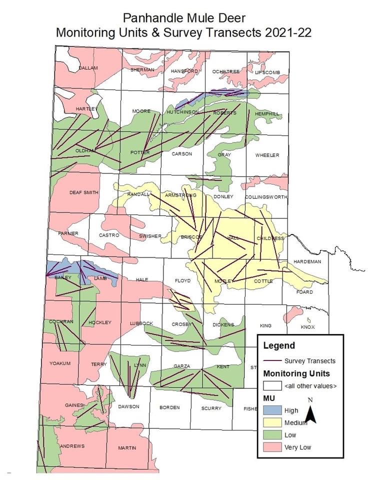
Mule Deer Survey Units
The Monitoring Units (MU) are based on deer densities, which consists of:
- High – <50 acres/mule deer
- Medium – 51-100 acres/mule deer,
- Low – 101-300 acre/mule deer
- Very Low with 301+ acre/mule deer.
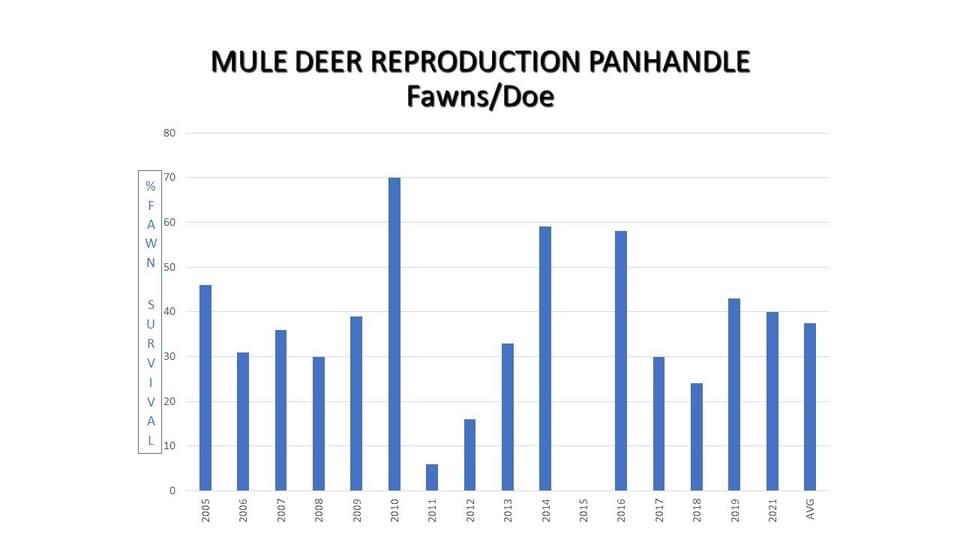
According to TPWD staff, “For the 2021-22 Season, we observed in the High MU: 45.45 acres/mule deer, 1 buck/7 does and 31% fawn survival, in the Medium MU: 263.71 acres/mule deer, 1 buck/3.5 does and 37% fawn survival and in the Low MU: 183.41 acres/mule deer, 1 buck/5.5 does and 37% fawn survival.
We calculated a lower deer density in the Medium MU compared to the Low MU this year, this could be attributed to poorer range conditions and fawn survival for the last couple of years due to drought or other factors.”
Mule Deer Surveys Necessary Management
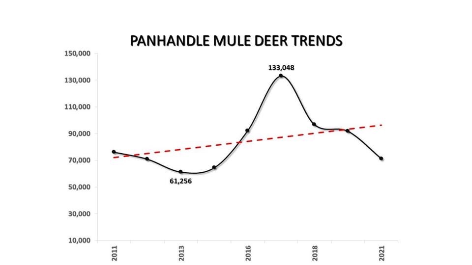
TPWD: “Across the Panhandle, we estimate this years’ mule deer population to be 72,171 total animals. This is down from the last several years. In 2017, we estimated the population at 133,048. We believe that low fawn survival and several significant weather events such as Winter Storm Uri and drought have negatively impacted survival and reproduction.
Considering the habitat conditions we are currently experiencing and how this might affect production and survival for the upcoming season, land managers and hunters might want to be conservative with their harvest during the 2022-23 Hunting Season.”